War map animation maker
Show where armies moved, which territory changed hands, and when. Describe the scene in plain English, check it in the live preview, and export a video for your edit.
Who it is for
History channels
Campaign and battle explainers where the viewer has to follow a route and a date.
Teachers and students
Lessons and presentations that show a war one phase at a time.
Newsrooms and analysts
Locator maps and background sequences that state positions without taking a side.
War map animation examples
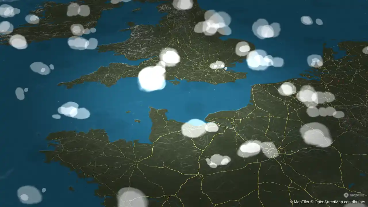
Portsmouth to Caen, War Room Theme
The War Room theme on dark terrain: a pin on Portsmouth, a red route across the Channel, and Caen marked with a pulse under drifting clouds.
- Aspect Ratio:
- 16:9
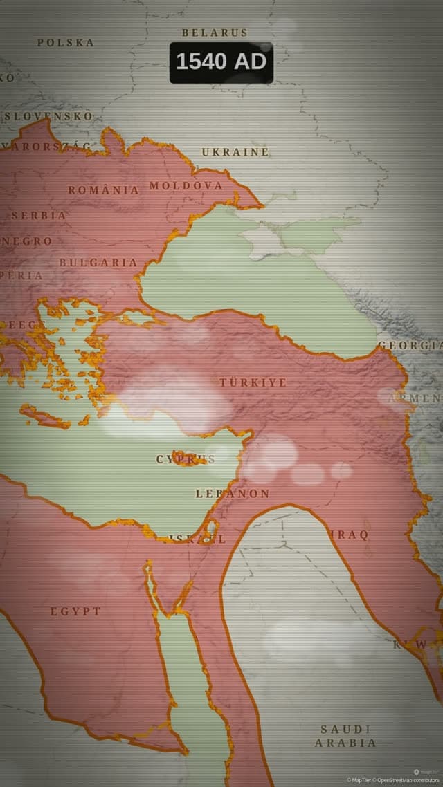
Rise of the Ottoman Empire
Historical borders animated year by year up to the empire's peak extent in 1683.
- Engine:
- Flat
- Map Style:
- Antique
- Aspect Ratio:
- 9:16
Prompt used for this videoshow the Ottoman Empire's growth over time and its peak in 1683
Routes, arrows and markers for a campaign
A war map is mostly movement. The Route action draws a line from one place to the next, leg by leg, and you add a waypoint for each stop on the way. Each leg has its own colour, width, opacity and pattern (solid, dashed, dotted or fade), so an advance and a withdrawal can look different on the same map. Put an arrow or an icon at the head of the line to show the direction of travel.
For anything the map data does not hold, the Draw action places lines, arrows, circles and free polygons by hand: an arrow for an offensive, a circle around a besieged city, a boundary that existed for only a few months. The Icon/Model action drops a marker from the icon library, or a 3D model, on an exact spot.
Territory that changes hands
Border outlines a country, a region or a city, and can show, trace or pulse that outline. Land fills the same area with a colour or with its flag, for the moments when the point is who held what. Shade dims everything outside a region, which keeps the eye on the theatre you are talking about.
For wars of the past, the Historical action plays the borders of an empire or a state forward through the years and shows the year on screen. The two templates on this page are built with it. Open one in the studio, then change the colours, the labels or the pacing.
Dates, names and pacing
A viewer follows a campaign through its dates. Label puts a short text on the map: a city, a date, a number. Text holds a longer caption or a quotation. Pause keeps the view still long enough to read them, and Hide layers removes a label, a route or a fill once its moment has passed, so the map does not fill up.
The camera moves between theatres with Fly to and Pan to, and Orbit circles a single place. A route never moves the camera by itself: add Fly along when the camera should ride the line.
A neutral map by default
A war map states facts, so its styling should not argue. Give each side one colour and keep it for the whole video. Write labels as short facts with a date. Leave out effects that suggest a feeling your sources do not support.
Animaps draws what you ask for. It does not check the history or the news behind a map, and it holds no live data about any conflict. Check every border, position and date against your sources before you export.
The War Room theme puts the map on dark terrain with red routes, as in the Portsmouth to Caen clip on this page. Cinematic Doc and Vintage Parchment are quieter themes for documentary and classroom work. Every theme stays editable in the studio.
Templates to start from
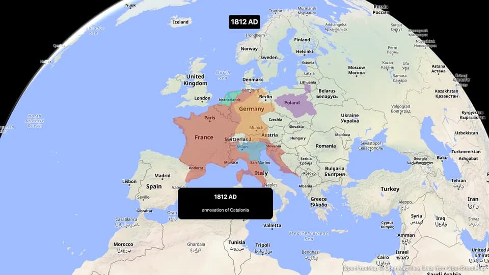
Napoleonic Europe
The French Empire and its rivals clash across Europe from 1804 to 1815.
Open in the studio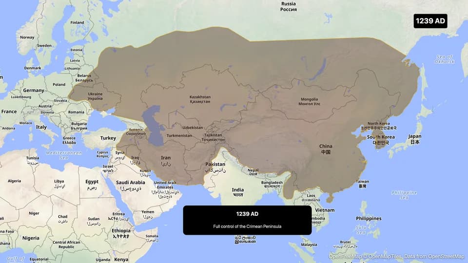
Mongol Empire
The largest contiguous land empire in history — from the steppes to China, Persia, and Europe.
Open in the studio
Example prompts to start from
These are starting points to edit, not the prompts behind the clips above. A link opens the studio and starts the generation.
- Show the Mongol Empire's growth over timeTry it in the studio
- Start over the English Channel. Add a label on Portsmouth, trace a route from Portsmouth to Caen, then add a label on Caen that says "6 June 1944"Try it in the studio
- Fly to France and fill it in blue. Trace a route from Paris to Moscow, add labels on Paris and Moscow, then zoom out to show EuropeTry it in the studio
- Fly to Waterloo in Belgium, add a label that says "18 June 1815", then zoom out and trace the border of BelgiumTry it in the studio
Questions and answers
Can I animate front lines and troop movements?
Yes. Use the Route action for a movement between named places, and the Draw action for lines, arrows, circles and polygons that you place by hand. Each one animates in, and Hide layers removes it later in the same animation.
Does Animaps have historical borders for past wars?
Yes. The Historical action plays the borders of an empire or a state through the years, with the year on screen. Coverage depends on the entity: the picker shows how many dated snapshots each one has before you add it.
Can I map a current conflict?
You can map any place, but Animaps holds no data about the state of a current conflict and no live front lines. You enter the positions, routes and dates yourself, from your own sources. Keep labels factual and dated.
How are disputed borders drawn?
Country and region shapes come from the map's border data, and the base map comes from its provider. Where a border is disputed, check how it looks in the preview. If your story needs another line, draw it with the Draw action.
What formats can I export for YouTube and Shorts?
Widescreen for a long video, vertical for a Short. Pick 16:9, 9:16 or 1:1 before you export and the camera frames for it. Exports are MP4 video, or a GIF for clips up to 6 seconds.
Can I make a war map animation for free?
Yes. The Free plan exports 1080p video up to 30 seconds long, with an Animaps watermark. Paid plans remove the watermark and allow longer videos.
Plans and limits are on the pricing page.
Learn the method
More map animations to make
- History map animation
- Travel map animation
- Flight path animation
- Map animation maker: every action and export option in one place
- Demo gallery: more clips, each with its own page