Animaps vs Mult.dev: A Trip Recap or a Map Animation Studio?
A comparison of Animaps and Mult.dev for animated map videos. One-time video packs versus monthly credits, GPX import and photos at each stop, transport modes, and which tool fits the video you are making. Verified August 2026.
Preview & Editor advantage
Draft with AI prompts or templates, then refine every animation step in real time (zoom, opacity, border width, colors, bearing, tilt). Credits are used only when you render the final video.
Animaps Team
Content Creator
Animaps vs Mult.dev: A Trip Recap or a Map Animation Studio?
Comparison verified August 2026, based on what each site and app store listing published at the time of writing. Both products change, so check their current pages before you buy.
TL;DR
Short version: Mult.dev animates a journey. You add stops, pick the transport for each leg, drop your photos on the map, and it produces a travel recap you can post. Animaps animates a map. Routes are one of 21 animation types, and the prompt gives you editable steps rather than a finished clip. If your video is your trip, Mult.dev is built for exactly that. If your video is about a place, a border, a region or a piece of history, that is a different tool.
Quick links:
- Map animation maker hub: Create animated maps online
- Comparison hub: Map animation maker alternatives
- Examples: Map animation examples gallery
Key differences:
- What it is built around: Mult.dev: a route with stops, photos and transport icons | Animaps: 21 animation types across camera, borders, fills, paths, labels and icons
- How you pay: Mult.dev: one-time video packs, "no subscription", valid 3 years | Animaps: monthly plans at $9.90 and $19.90
- Import your GPS tracks: Mult.dev: GPX, KML and GeoJSON on Pro | Animaps: no import workflow
- Photos at each stop: Mult.dev: yes, 1 to 4 per location | Animaps: not a photo workflow
- Runs on your phone: Mult.dev: iOS and Android apps plus web | Animaps: browser only
- Best fit: Mult.dev for travel recaps and route storytelling | Animaps when the map itself is the subject
You are looking at two tools that both put an animated line on a map, and that is roughly where the overlap ends.
Mult.dev calls itself "Travel map animation" and describes the job as "Turn your trip into a clear, beautiful map animation for sharing or presenting." Its own word for the experience is "Zero-config". Animaps is a map animation studio: you describe a sequence in plain English, the AI writes steps, and you edit those steps against a live preview.
This comparison covers what each one is built to do, what each publishes about price, what you can and cannot import, and which one fits the video you are actually making. Everything below about Mult.dev comes from their own public pages, their FAQ and their app store listings in August 2026, and anything we could not read directly is flagged rather than guessed.
Quick Comparison
| Factor | Animaps | Mult.dev |
|---|---|---|
| Runs in browser | Yes | Yes, plus iOS and Android apps |
| Text to animation | Yes, the prompt writes editable steps | An AI assistant builds the route from a written journey |
| Live preview | Yes, before you spend an export | Yes, their FAQ tells you to check the route in Preview |
| Editor after the AI | Step editor with per-step timing and targets | Route builder, transport per leg, and an Options menu |
| Free tier | 12 credits per month, 1080p, watermarked | 5 videos, 768p, 30 FPS, logo required, 10 max map nodes |
| Paid prices published | Yes ($9.90 / $19.90 per month) | Pack sizes shown on the web pricing page without amounts |
| Payment model | Monthly or annual subscription | "One-time purchase, no subscription", packs valid 3 years |
| Top resolution | 1440p on Pro | "1920p" on Pro, "768p" on Free, in their own words |
| Frame rate | 60 FPS option | 30 FPS Free, 60 FPS Pro |
| Maximum clip length | 30s Free, 45s Starter, 60s Pro | Not stated on the pages we read |
| GPS track import | No | GPX, KML and GeoJSON on Pro (Strava, Gaia, Komoot named) |
| Your own photos | Not a photo workflow | 1 to 4 images per stop, 100 images on Pro, 10 on Free |
| Transport modes | Path and route animations without vehicle icons | "11 modes of transportation", plus land and sea routes on Pro |
| Globe view | Yes, flat map or globe | Not described as a globe view on the pages we read |
| Custom colours | Yes, including per-step | Pro only, per their own feature table |
What Each Tool Is For
Mult.dev is a travel storytelling tool with a very clear shape. Their FAQ walks through the flow: you tap Create Animation, build the route with the Route button, add one to four images per location, pick the transport for each leg, then open Options for style, colours, music, speed and labels, preview it, and export. Their answer on transport is specific: "Click on the airplane icon and choose one of the 11 modes of transportation." Their Google Play listing adds the import side, naming GPX, KML and GeoJSON files "from trackers (like Strava, Gaia, Komoot)".
There is an AI assistant in there too, and it does one job: it turns a written journey into a route. Their FAQ describes writing the journey in the Options menu, choosing a transport mode, and pressing the arrow. They add their own caution, which is worth quoting because a lot of tools do not say it: "Please note that there may be inaccuracies, so make sure to check your route and video in Preview before exporting."
Animaps treats the route as one animation among many. You describe a sequence, the AI produces steps, and the editor lists every step next to a live preview so you can change a duration, retarget a camera move or swap a colour and watch the result before exporting. It carries 21 built-in animation types spanning camera moves, border tracing, land fills, path tracing, historical border timelapses, labels, icons and scenes that run several of them at once, and it renders both a flat map and a globe.
The honest summary is that Mult.dev is the better product for the video "here is the trip I took". Animaps is the better product for the video "here is what happened in this part of the world".
Pricing Side by Side
Animaps publishes its prices.
| Tier | Price | What you get |
|---|---|---|
| Free | $0 | 12 credits per month, 1080p, watermarked, 30 second maximum |
| Starter | $9.90 per month, or $99/year | 120 credits, up to 1080p, no watermark, 45 second maximum, unlimited AI prompts (1 credit each) |
| Pro | $19.90 per month, or $199/year | 250 credits, up to 1440p, no watermark, 60 second maximum, unlimited AI prompts (1 credit each), priority support |
Mult.dev sells video packs rather than a subscription, and that is the more interesting difference. Their pricing page states "One-time purchase, no subscription" and asks you to "Choose your pack size", with Free, and Pro packs of 5, 25 or 100 videos. Their FAQ says "Each package is valid for 3 years from the date of purchase" and that packs do not auto-renew, while noting that subscriptions exist separately through Apple ID.
When we loaded their web pricing page in August 2026, the comparison table rendered the pack sizes and the feature rows but no dollar amounts, so we are not going to quote a web price. The in-app purchase list on their iOS App Store page did show figures at the same time: Pro 5 at $7.99, Pro 25 at $19.99 and Pro 100 at $44.99, alongside subscription entries. Treat those as the App Store's numbers, in US dollars, on that day.
The feature split between Free and Pro on their own table is clear enough to plan around. Free gives you 5 videos, 10 maximum map nodes, 768p, 30 FPS, 10 images, and the Mult.dev logo marked "Required", with GPX/KML/GeoJSON import, custom colours, land routes and sea routes all excluded. Pro raises that to 100 map nodes, "1920p", 60 FPS, 100 images, an optional logo, and all four of those excluded features switched on.
If you make two travel videos a year, a one-time pack is plainly the cheaper shape and a subscription is the wrong instrument. If you make map videos most weeks, monthly credits that refresh work out differently. Neither model is better in the abstract; they are priced for different frequencies.
Export and Resolution
Animaps exports MP4 up to 1080p on Free and Starter and up to 1440p on Pro, plus GIF capped at 6 seconds, in 16:9, 9:16 and 1:1, with a 60 FPS option. Clip length is capped by tier at 30, 45 and 60 seconds.
Mult.dev states "768p" at 30 FPS on Free and "1920p" at 60 FPS on Pro in its own comparison table. We are quoting those labels as written rather than converting them, because "1920p" is not a standard height and we would be guessing at what it maps to. Their Reddit post about the launch mentions "Vertical or horizontal format, adjustable resolution and FPS", and the pages we read do not state a maximum clip length, so we are leaving that cell empty rather than inventing one.
If your delivery target is 4K, neither tool advertises it on the pages we read.
The Things Only One of Them Can Do
This is where a comparison earns its keep, because the two feature lists barely touch.
Mult.dev can do things Animaps cannot. You can import a GPX, KML or GeoJSON file straight from Strava, Gaia or Komoot and animate the track you actually walked or rode. You can attach up to four photos to each stop so the recap carries your images, not just the geography. You can set a different transport mode for each leg from eleven options, and Pro adds land routes and sea routes so a ferry crossing does not draw as a straight line through the water. You can add music. You can do all of it on a phone, on the trip, from an iOS or Android app. Animaps has none of that: no file import, no photo workflow, no per-leg vehicle icons, no mobile app.
Animaps can do things Mult.dev is not built for. Border tracing and land fills for a country or region. Historical border timelapses. Label and icon placement you position yourself. A globe view alongside the flat map. Per-step durations you can set to hit a narration cue exactly, and a hard tier cap you can plan a voiceover around. Twenty animation types rather than one route with decorations.
Neither list is a criticism. They are two different videos.
How You Fix a Result You Do Not Like
In Mult.dev, the route is yours to begin with. You placed the stops, so correcting one is direct: change the stop, change the leg, change the transport. Their FAQ handles the "I already exported it" case by pointing you at My Videos and a "Create copy" action, which is a sensible answer for a pack-based product where each export costs a video from your pack.
The one place their own documentation asks you to be careful is the AI route builder. Their wording, again, is "there may be inaccuracies, so make sure to check your route and video in Preview before exporting". That is the right instinct and it is worth respecting, since an export spends part of a finite pack.
In Animaps, the AI writes the steps and you edit them. If the zoom lands one level too far out, or the pan needs to finish half a second earlier, you change that step and watch the preview without re-running the generation. This matters most when the timing is not negotiable: a narrated explainer where a move has to land on a specific word, or a clip that must be exactly 22 seconds.
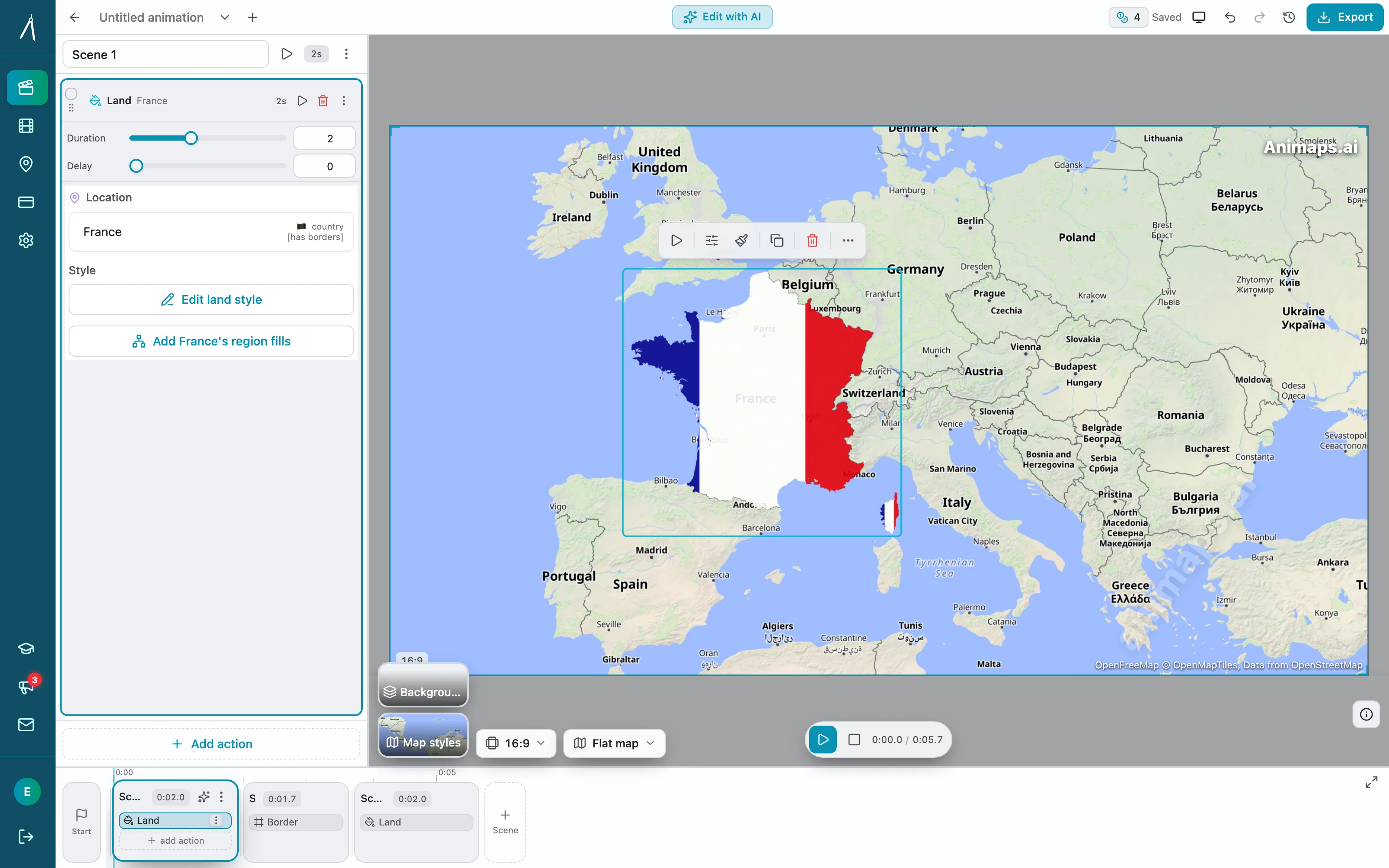
Both tools let you see the result before you spend an export, which is the part that actually protects your credits.
Where Each One Is Stronger
Mult.dev is stronger on
Real trips. Stops, photos, transport per leg, music, and a recap shaped like a journey. That is the whole product and it is coherent.
Importing what you recorded. GPX, KML and GeoJSON from the trackers people actually use.
Paying once. A pack that lasts three years and does not renew is a genuinely different offer in a category full of subscriptions.
Being on your phone. iOS and Android apps, not just a browser tab.
A clear commercial answer. Their FAQ says "Yes you can use generated videos for any purpose. Post it in social media or use in video editing. It is yours", with a request for a social credit rather than a requirement.
Animaps is stronger on
Maps that are not journeys. Borders, fills, regions, historical change, labelled geography.
Animation range. 21 animation types, including scenes that run several camera moves at once, and border timelapses.
Exact durations. Per-step timing, and tier caps at 30, 45 and 60 seconds you can build a script around.
Flat map and globe from one project. Both views are first-class.
Published subscription pricing. $9.90 and $19.90 per month, with the credits, resolution and duration each tier includes stated up front.
Who Should Choose Which
Pick Mult.dev if
You are making a video about a trip. You have a GPX file, or photos from each stop, or a route with a plane leg and a ferry leg that should look like a plane leg and a ferry leg. You want to build it on your phone. You make a handful of videos a year and would rather buy a pack than hold a subscription.
Pick Animaps if
The map is the subject rather than the trip. You need borders, fills, historical change, a globe, or labels you place yourself. You are cutting to narration and the timing has to be exact. You make map videos often enough that a monthly credit allowance beats a pack. You want the prompt to be a starting point you can edit rather than a finished result.
Honestly, some people should use both
A travel channel that posts trip recaps and also explains where a region is, what changed there, and why, is describing two different videos. Nothing stops you from making the recap in the tool built for recaps.
FAQ
Is Mult.dev an AI tool? Partly. Their AI assistant turns a written journey into a route, and their FAQ asks you to verify the result in Preview because "there may be inaccuracies". The rest of the product is a manual route builder with an Options menu.
Can I import a GPX file into Animaps? No. Mult.dev supports GPX, KML and GeoJSON import on its Pro packs. Animaps has no file import workflow, so a recorded track is not something you can drop in today.
Can I put my own photos in the animation? In Mult.dev, yes: one to four images per stop, up to 100 images on Pro and 10 on Free. Animaps works from map data, locations, labels, icons and drawn elements rather than uploaded photos.
Which one is cheaper? It depends entirely on how often you export. Mult.dev sells one-time packs valid for three years, and its App Store in-app purchase list showed Pro 5 at $7.99, Pro 25 at $19.99 and Pro 100 at $44.99 when we checked. Animaps charges $4.90, $9.90 or $19.90 per month for 50, 120 or 250 credits, and also sells one-time credit packs ($10/90 up to $100/1300) that never expire. Occasional use favours a pack; regular use favours a subscription.
Do both have a free tier? Yes, and they are shaped differently. Mult.dev's free tier gives 5 videos at 768p and 30 FPS with its logo required, capped at 10 map nodes and 10 images, without import, custom colours or land and sea routes. Animaps gives 12 credits per month at 1080p with a watermark and a 30 second cap.
Can I use the videos commercially? Mult.dev's FAQ says the videos are yours for any purpose and asks for a social credit rather than requiring one. Animaps removes the watermark on Starter and above. Check the current terms on each site before client delivery.
Which one does a globe? Animaps renders both a flat map and a globe. The Mult.dev pages we read describe map styles rather than a globe view, so we are not claiming either way beyond that.
Can either export 4K? Not that we could verify. Animaps caps at 1440p on Pro. Mult.dev's own table says "1920p" on Pro, and we are not going to interpret that label for them.
Does Mult.dev have an app? Yes. Their FAQ says "We provide an iOS and Android app. Also a web version is available." Animaps runs in the browser only.
The Bottom Line
Mult.dev knows exactly what it is. It is the tool for the video where the trip is the story: your stops, your photos, your GPX track, eleven transport modes, land and sea routes, on your phone, paid for once. Inside that job it is well shaped, and the honesty in its own FAQ about AI route inaccuracies is a good sign about how it is built.
Animaps is a map animation studio. Routes are one of 21 animation types, alongside border tracing, land fills, historical timelapses, labels, icons and scenes that run several camera moves at once, on a flat map or a globe, with a step editor and a live preview so the clip lands on the exact length and the exact frame you needed.
Pick by the video, not by the feature count. If the answer to "what is this about" is your journey, use the journey tool. If it is a place, a border or a period of history, you want the map tool.
Related Articles:
Keywords: mult.dev alternative, animaps vs mult dev, mult dev review, travel map animation tool, gpx to video, animated travel map, map animation tool comparison
Tags
Related reading
Animaps vs anim8map: Travel Route Videos or a Full Map Studio?
These two tools are not built for the same job. anim8map makes animated 3D travel routes with stops, travel modes and your own photos, and sells per video or as a six-month pass. Animaps is a general map animation studio covering camera work, borders, labels and highlights on a monthly subscription. For a single trip recap, paying once beats subscribing. For ongoing map content, the subscription is the cheaper shape.
10 Ways Travel Bloggers Use Animated Maps (And How You Can Too)
Travel bloggers face a unique challenge: how do you make someone *feel* a journey they haven't taken? Static photos show destinations. Written stories describe experiences. But animated maps? **They transport viewers into your journey**, transforming passive readers into active participants following along your path. In 2026, animated maps have evolved from nice-to-have embellishments to essential storytelling tools.
Animaps vs AnimateMyMap: Which Map Video Tool Fits Your Work?
Both Animaps and AnimateMyMap make map videos in a browser, and neither needs After Effects. The difference is where you start: Animaps turns a written description into an editable animation, while AnimateMyMap is built around camera modes and layers you place yourself. AnimateMyMap Pro exports 4K where Animaps caps at 1440p, and it does not publish dollar amounts for its paid tiers.
Browse every article in the Animaps blog.